Point Cloud Sharing Opens Reality Capture to Small Firms
Reality capture has traditionally been too expensive and complex for many small firms to adopt directly, but that is beginning to change. Nick Seres of DronePoint and Professional Drafting Service works primarily with architects, engineers, and other AEC firms—often businesses with only a few employees—that lack the staff, capital, or time to build their own reality capture capabilities. By providing scanning, processing, and deliverables as a service, companies like DronePoint allow these smaller firms to benefit from high-quality reality capture without having to develop the expertise and infrastructure in-house.
Reality capture has traditionally been too expensive and complex for many small firms to adopt directly, but that is beginning to change. Nick Seres of DronePoint and Professional Drafting Service works primarily with architects, engineers, and other AEC firms—often businesses with only a few employees—that lack the staff, capital, or time to build their own reality capture capabilities. By providing scanning, processing, and deliverables as a service, companies like DronePoint allow these smaller firms to benefit from high-quality reality capture without having to develop the expertise and infrastructure in-house.
In this Q&A, Seres explains that one of the remaining challenges is what he describes as the “last mile” of reality capture: delivering complex datasets in a format that customers can actually use. Processing still takes place on powerful desktop workstations, but traditional delivery often requires clients to download large datasets, install specialized software, understand unfamiliar file formats, and learn tools that may be excessive for relatively simple tasks. For a small firm with limited resources, those requirements can undermine much of the value that reality capture is supposed to provide.
Seres has addressed that delivery problem with Stitch3D, a cloud-based point cloud sharing platform that allows clients to access reality capture data directly through a web browser. Rather than changing how DronePoint processes its data, Stitch3D changes how clients interact with the finished dataset. Customers can quickly revisit existing site conditions, take measurements, and access the underlying point cloud without specialized CAD or point-cloud software—whether they are in the office, in a truck, or standing on the jobsite. For Seres, making the data this accessible significantly expands the range of firms that can practically benefit from reality capture while allowing them to remain focused on their core work.
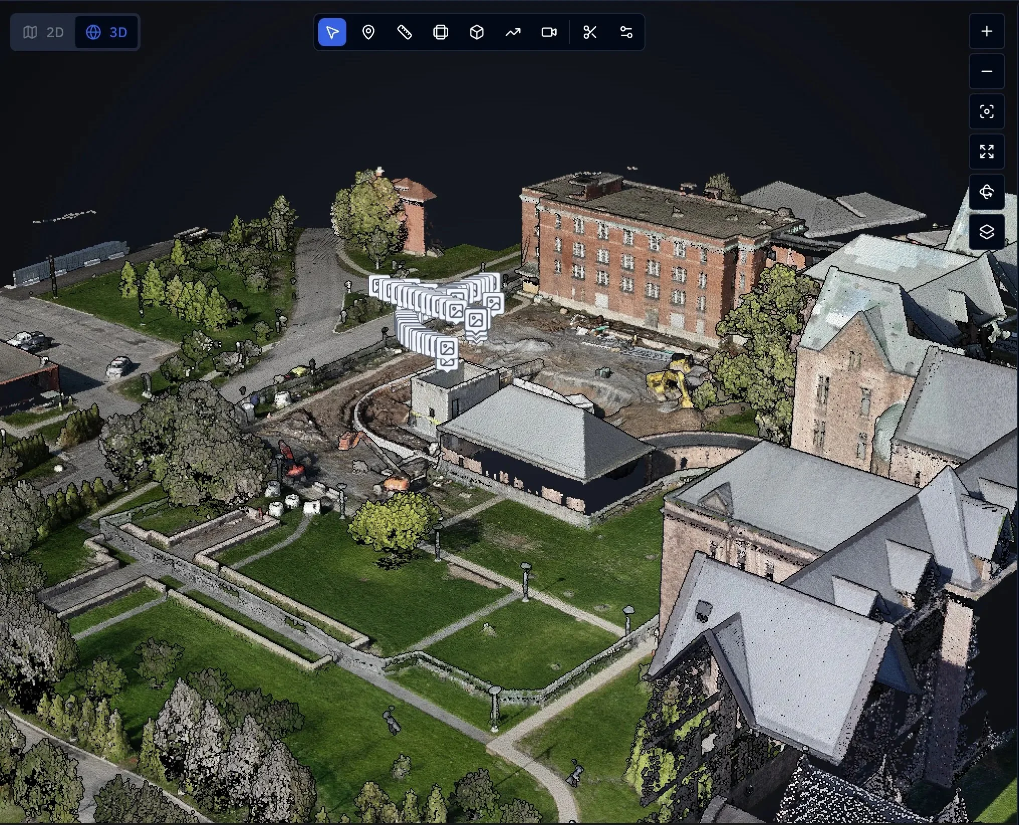
RGB point cloud and locations of georeferenced photos displayed in Stitch3D.
The following is an interview between Nathan Roe of Lidar News and Nick Seres of DronePoint and Professional Drafting Service:
Can you please describe what type of work you do and why laser scanning is important for your clients?
We operate two companies that feed each other. Professional Drafting Service (PDS) has almost 40 years of experience supporting architects, engineers, developers, contractors, and municipalities with CAD drafting, 3D modeling and rendering for architectural visualization, and terrestrial LiDAR scanning. DronePoint started as the aerial side of that reality capture work — using LiDAR from above to build a more complete point cloud of our projects, and producing high quality, highly accurate orthomosaics for site planning. It has since grown into a broader service offering than we anticipated, which lets us deliver a more complete package to our clients.
Laser scanning matters to our clients because most of them are single-person architects and engineers or small firms that don’t have the staff, capital, or time to document a building or site with the detail, speed, and accuracy we can with LiDAR. It lets them stay focused on their business and their customers while knowing that what gets delivered is as accurate as possible, without stretching the project’s timeframe or the budget.
RGB point cloud and locations of georeferenced photos displayed in Stitch3D.
Can you talk about the data that you collect, process, and/or deliver? Lidar, photogrammetry, CAD, engineering drawings, photos, etc.? And what is the predominant method you collect these datasets (drones, TLS, 360 cameras, gaussian splat, mobile, etc.)?
We use terrestrial and aerial LiDAR, photogrammetry, and 360 cameras to produce existing conditions and as-built drawings, 3D models and renderings for architectural visualization, full sets of engineered drawings, and construction progress monitoring. We pride ourselves on being able to provide a complete service to our clients across the AEC industry.
Terrestrial scanning is still our predominant method — it is where the tightest tolerances are and where most of our work originates. That said, drones have been rapidly climbing the ranks, and on a growing number of projects we run both and register them into a single dataset. That is where having the two companies under one roof really pays off.
We are also interested in gaussian splatting and expect to adopt it soon. The draw for us is virtual tours — it would give us a different way to showcase a space than our current 360 photo and video deliverables can.
We process most of our data in-house so that we control the timeframe, the cost, and the accuracy for our clients. When something has to be processed outside the office, we choose our partners carefully so that the standard doesn’t change.
It seems like most people in the industry are still operating on desktop-based workflows. Why do you think the industry has been slow to adopt digital records on the cloud?
The desktop isn’t really the problem. Processing a dataset that size is going to stay on a workstation for the foreseeable future, and we still do all of our processing and deliverable prep that way. Where desktop workflows fell down for us was delivery. Handing a client a hard drive and a proprietary viewer means you have just become their IT support, and that is a very different job than the one they hired us for.
I think the industry has been slow to separate those two things. People hear “cloud” and assume you are asking them to move their entire processing pipeline, when really the part that needs to move is the last mile — getting the data in front of the client in a form they can actually use. That is where cloud-based point cloud sharing solutions have become both practical and affordable.
Part of it is also that the early cloud options were not much better than the hard drive. We tried switching to one, and the end user had to create an in-depth account before they could see anything, and then the interface was too difficult to navigate once they got in. We had almost given up on cloud-based solutions entirely. If your first attempt costs you a meeting and a frustrated client, you go back to what you know.
There is also a real hesitation about where the data lives and who can get to it, especially on municipal, utility, or secure sites. That concern is legitimate and I don’t think it gets addressed head-on often enough.
Point-to-point distance measurement in Stitch3D, including slope of line.
Can you talk about the software suite that you’re using and walk me through the workflow of data processing to data delivery?
For terrestrial LiDAR we run Trimble X7 and X9 laser scanners, using Trimble Perspective in the field to collect, register, align, and georeference the data, then Trimble RealWorks to process and prepare it for its intended use case. For aerial LiDAR we process in DJI Terra and prepare the data in Trimble Business Center. Once everything is processed, we run a QA/QC check to confirm the data is aligned and georeferenced correctly and that we are inside the accuracy the project calls for before we move on to deliverables.
From there, most projects get a cleaned RCP file for AutoCAD or Revit, where we produce the relevant 2D and 3D documentation the project requires. The registered dataset also goes up to Stitch3D, a cloud-native point cloud sharing platform we use to host and deliver reality capture data, so the client can be looking at the source data in a browser while we are still drafting from it.
The Lipsey Architecture Center is a good example of the whole chain. Allied Mechanical needed to fabricate and install mechanical plenums into inserts in a foundation that had already been poured, so there was no room to be wrong. We scanned the existing concrete foundations — 39 station setups, about five hours of field work, over 300 linear feet of foundation, and 373,742,405 points — and then modeled the existing conditions from that data so their fabrication team could model the proposed plenums into the existing cutouts to a quarter inch.
Inspecting georeferenced photos and metadata along with RGB point cloud in Stitch3D.
How has Stitch3D helped your business? And what have your customers been saying about receiving a deliverable on Stitch3D?
Stitch3D has helped our business immensely. Before, delivering a point cloud often meant scheduling a meeting just to help the client install the viewing software and walk them through navigating the data. There were always issues with either hardware compatibility or getting them comfortable in the interface, and it was becoming more cumbersome every year. Once we found Stitch3D, basically all of those issues went away. Anyone can access a point cloud or orthomosaic with just a web address. The interface is significantly easier to use, especially if you aren’t used to moving around inside a point cloud.
Our clients who are using it are very pleased with the change. It is much easier for them to log on and check on something that came up in a meeting than it is to call us and try to describe what they need over the phone or by email. On the Lipsey Architecture Center project, Allied Mechanical was back in the platform repeatedly for measurements and to verify site conditions.
Two reasons our clients want the point cloud and not just the Revit or AutoCAD deliverable. The first is that not all of them are running Revit or AutoCAD to begin with, so they need another way to get at the data. The second is that even for the ones who are, it is simpler and faster to open the point cloud in Stitch3D and pull a measurement than it is to do the same thing in CAD — and they can do that from the office, from the truck, or standing on the site.
The part we did not anticipate is what it does for the people who were never on site. They can experience the space in a way that a set of photos or a walkthrough video simply cannot deliver. Stitch3D has given our clients direct access to their own data.
The platform has also broadened a lot in the time I have been on it. When I started it was point clouds and raster imagery. Since then they have added ground control point files, media including photos and panoramas, documents like PDF, Word, PowerPoint, and Excel, and most recently vectors. While we cannot import AutoCAD drawings or Revit models directly into the platform yet, we are able to export our site drawings out of Civil 3D as SHP files and bring them in, so we can view the linework right over the point cloud and the raster image. It is getting closer to being the one place a whole project can live.
Cross section view of point cloud visualized by elevation in Stitch3D.
Where do you see software like Stitch3D going in the future?
Up! I have only been using the software since October 2025, but in that time they have released a ton of great updates, and they have many more planned. I have given them numerous feature requests, and not once have they told me “no, we can’t or won’t do that,” and some of those requests seemed pretty difficult to pull off. They care about their customers’ needs and wants, they listen, and they ask, “what can we do to make the platform better for you?”
For a shop our size, that responsiveness matters more than any single feature. We are not big enough to build our own tooling, so the platform moving in the direction we actually work is what keeps us on it.
How do you see the industry growing in the future?
The industry is already growing quickly. As reality capture hardware and software get more capable, they also get more accessible to people who were priced out of it before. It is going to become a standard line item on projects instead of a specialty add-on, and projects that never used it will start finding their own use cases for it.
I would like to see reality capture become standard on every AEC project. There is no good reason it shouldn’t be.
It will take companies like Stitch3D to keep the industry growing. Companies need to grow with their customer base, not wait for them to catch up.
Anything else we didn’t ask that you’d like to touch on?
Two things. The first is that reality capture usually gets talked about as something for large firms on large projects, and that is not who we work with. Most of our clients are one or two people, and Buffalo is not a top-ten market. The reason this works here is that the hardware and the delivery platforms have both come down far enough in cost and complexity that a solo architect can put a scan on a renovation and have it pay for itself in avoided site visits and change orders. That shift is what actually grows the industry, and I don’t think it gets covered much.
The second is that the constraint now is people, not equipment. Anyone can buy a scanner. Knowing where to set it up, how many setups a space actually needs, and what the client needs out of the data at the end is the part that takes time to build, and there is nowhere local to hire it from — so we are training it in-house. I think that is going to be the real limit on how fast this industry can grow.
Project reference and imagery
Featured project: Lipsey Architecture Center — terrestrial scan and 3D model of existing concrete foundations for Allied Mechanical, for fabrication and installation of mechanical plenums into previously poured foundation inserts.
Project imagery and the registered point cloud are available in Stitch3D at the link below.
The original article and all original content can be found here.